Join Our Neighborhood Alliance
Get the Latest Alerts and Updates
25 Top Problems With the City's Draft Mitigated Negative Declaration
The City released the Draft MND for Vello Retreat (PROJ-23-0414) on September 2. These 25 are drawn from a resident's 50-item review of the Draft MND and its appendices, submitted to the City for the record. Item numbers refer to that review.
Evacuation
- 1
Cedar Street, the project's main way in and out, was never studied.
The evacuation analysis (Appendix I) gives no width, parking condition, capacity or travel time for Cedar. With cars parked on both sides, a narrow stretch of Cedar leaves about 13 feet 2 inches of clear driving width.
Review item #17
- 2
The four-hour evacuation times are left out of the Draft MND.
Appendix I's own exhibits show about 248 minutes to clear the corridor south of Seneca without the project and 267 with it at 1 p.m. (247 and 275 at 9 p.m.). The Draft MND reports only the added minutes.
Review item #25
- 3
The City's own General Plan study finds North Ventura Avenue over capacity, and it isn't cited.
General Plan Appendix B (April 2024) finds about two miles of North Ventura Avenue over capacity in a northern-hillside wildfire, and 0.7 mile over capacity on an ordinary weekday evening. The project analysis concludes the road has enough capacity without reconciling the two.
Review item #26
- 4
The better evacuation numbers depend on a police officer nobody is required to provide.
Appendix I cuts the project's delay by 50% or more by placing an officer at Ventura and Seneca and converting the center turn lane. Neither is a mitigation measure or condition, and Ventura/Seneca isn't one of the City's six pre-identified Zone 1 traffic-control points.
Review item #10
- 5
An "Evacuation Plan" scenario gets credit, but was never modeled.
The Wildfire section says the analysis evaluated "a more likely scenario" using the City's adopted Emergency Evacuation Plan. Appendix I contains no such scenario, yet the less-than-significant finding rests on it.
Review item #43
- 6
No one analyzed fire engines coming in while residents are trying to get out.
State fire-safe rules (Title 14 §1273.00) require roads to serve firefighting equipment and civilian evacuation at the same time. No part of the project's evacuation analysis looks at two-way emergency traffic on Cedar.
Review item #21
- 7
One in five evacuating cars is sent through a locked gate with no opening time and no one in charge of it.
Appendix I routes 20% of the project's evacuation traffic through the School Canyon Road gate. The record doesn't say who opens it, how long that takes, or what happens if it fails or loses power.
Review items #5, #11
- 8
The legal right to use School Canyon Road is never identified.
Aera/CRC objected in writing in June 2025 to emergency use of the road, and later correspondence did not withdraw that objection. The project's only second exit depends on a right the Draft MND never names.
Review item #12
- 9
The evacuation study contradicts itself: 18 minutes or 11?
Page 33 of Appendix I says the project adds 18 minutes north of Seneca at 9 p.m. Exhibits 21 and 22 and the page 34 summary say 11. Decision-makers need to know which number the finding relies on.
Review item #6
- 10
The Draft MND says the project won't change existing roads. It will.
It concludes emergency access is unaffected because the project "would not modify existing roadways," while the same document says School Canyon Road will be graded, repaved and gated, with lane closures on School Canyon and Cedar during construction.
Review item #44
State Fire-Safe Rules
- 11
Neither "Title 14" nor "dead-end" appears anywhere in the Draft MND.
State fire-safe rules cap dead-end roads at 800 feet for lots zoned under one acre. If School Canyon Road doesn't count as a second connection, Cedar alone runs about 1,035 feet from the project line to Seneca, before adding any project street. Fire Department staff acknowledged the dead-end layout in June 2025.
Review items #28, #36
- 12
Cedar with cars parked doesn't meet the state's two-lane width standard.
Title 14 calls for two 10-foot traffic lanes on the roads it covers. At about 13 feet 2 inches of clear width with cars on both sides, Cedar doesn't provide that, and the Draft MND doesn't say what standard or exception the City is applying.
Review item #35
- 13
Internal alleys are narrower than the fire plan requires.
The Fire Protection Plan requires fire access roads at least 24 feet wide. The revised site plan narrows most internal alleys from 26 feet to 20.
Review item #2
- 14
The fire plan describes an earlier version of the project, and mentions a different development.
Appendix K uses an outdated unit mix, a 35-foot height limit (the project now seeks 38), a different case number, and a leftover reference to fuel treatments for "the Canyon Hills development."
Review item #32
- 15
The City's new Safety Element is never analyzed.
The 2050 General Plan Safety Element took effect November 20, 2025, with policies on fire protection, single-access neighborhoods and evacuation modeling. The Draft MND checks other General Plan elements, but not this one.
Review item #27
Our Neighborhood and the Public Process
- 16
Solana Heights' 2013 approval, and the Cedar-to-Mohawk connection, are missing.
The Draft MND never mentions the 2013 conditions that approved Solana Heights, the Cedar-to-Mohawk connection the City asked for in November 2023, or the developer's request to be relieved of it. Yet it concludes the project "would not interfere with existing and planned roadway" facilities.
Review item #50
- 17
The fire-access conditions come out after public comment closed.
City staff said the fire-access requirements will be written into the Conditions of Approval, released with the hearing materials after the comment period. The public can't comment on requirements it hasn't seen.
Review item #16
- 18
A required no-parking zone on Cedar isn't disclosed.
The City's October 2024 letter required no-parking signs and a double-yellow center line on Cedar between Alabama Street and the project's "A" Drive. The Draft MND doesn't disclose that change or the curb parking it would remove.
Review item #29
- 19
Will construction trucks use Cedar? The Draft MND says both yes and no.
Page 126 routes construction traffic via North Ventura Avenue and School Canyon Road, with no staging on Cedar. Page 129 says "via Cedar Street or School Canyon Road." Construction runs about 21 months and includes hauling up to 6,100 cubic yards of impacted soil.
Review item #9
Soil Contamination
- 20
Next-door neighbors are left out of the toxic-exposure analysis.
Soil vapor on the site measured 8,920 µg/m³ of ethylbenzene in 2020, against a 37 µg/m³ residential screening level. The hazards discussion names only future residents and construction workers as at risk, with no toxic-air calculation for the existing homes next to the dig.
Review item #23
- 21
No air monitoring or neighbor notice while contaminated soil is dug up.
The mitigation measures don't require perimeter air monitoring, action levels, stop-work triggers or notice to residents. Contamination reaches about 21 feet in one area and at least 24 feet near Tank 4.
Review item #24
- 22
Chlorinated solvents found on site are missing from the contaminant list.
PCE exceeded the residential screening level in three 2021 vapor samples, and chloroform and bromodichloromethane exceeded theirs in 2020. The Draft MND lists only petroleum-related chemicals, though it notes one sump took "unknown laboratory chemicals."
Review item #47
- 23
No vapor testing after the cleanup.
The applicant's own consultant recommends re-testing soil vapor after remediation to confirm a standard vapor barrier is enough. Mitigation measure HAZ-3 requires only a pre-grading assessment that can be "a screening analysis, only."
Review item #48
- 24
The deepest contamination was never fully mapped.
The Phase II report says contamination near Tank 4 continued past the drill rig's 24-foot limit and that more delineation was required. The Draft MND doesn't identify any follow-up investigation that completed it.
Review item #33
- 25
No one has been named to oversee the cleanup.
Mitigation measure HAZ-1 leaves the oversight agency to a future agreement, and the Soil Management Plan hasn't been written. The state Department of Toxic Substances Control flagged the same gap in its September 11, 2026 comment letter.
Review item #15
Facts as we know them
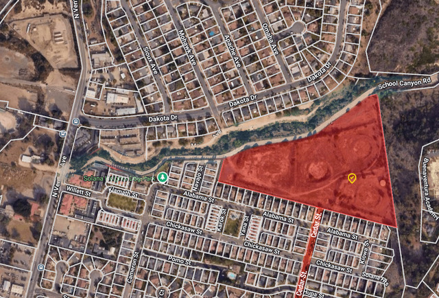
- Proposal: 117 new homes are proposed on 17.61 acres bordering Alabama, Navajo, and Cedar Streets — nearly tripling the number of households that would depend on our single shared road (Cedar St.) during an emergency and for daily access.
- Density: 6.64 units per acre, packed onto a site with only one way in and one way out. More density means more cars competing for the same narrow street the moment it matters most.
- Construction & Emergency Access: Aera Energy — now California Resources Corporation (CRC) — holds the recorded legal easement to School Canyon Road (Ventura County Instrument No. 98-065449) and has formally denied the developer's request to use it, for construction traffic or for emergency fire access. As proposed today, this development's only way in or out is Cedar Street and the project continues to move forward with the City planners.
- City/County Jurisdiction: This land sits outside Ventura city limits entirely — it's unincorporated County land the City is actively trying to annex (Case No. ANEX-09-23-0002) specifically to approve this project.
- Fire Access — We Measured It Ourselves: Cedar Street narrows to just 13 feet of clear driving space once cars are parked on both sides — 7 feet short of the state's 20-foot fire-code minimum. Independent modeling estimates that evacuating Vello Retreat via Cedar Street, where traffic merges from Alabama and Chickasaw streets, could take 30 to 50 minutes. A fast-moving wildfire starting two miles away could reach the neighborhood in roughly 36 minutes.
- New The City's Own Escape Route Doesn't Reach Us: The City's General Plan requires a second connector road linking Cedar Street to Mohawk Avenue — and the City's own Emergency Evacuation Plan names that corridor as one of only four "major thoroughfares" for our entire evacuation zone. That connector has quietly disappeared from the developer's plans, with no explanation on record.
- New Mohawk Connector Deletion Request — Still Pending?: For over two years, the City has been sitting on a builder request to erase the Mohawk connector, leaving a gated 20-foot emergency route onto a private oil-field road in its place. We've asked whether it's still pending and haven't heard back — and if it's granted quietly, that decision gets made without us. [Learn More]
- New The Project Started Much Smaller: The original Vello Retreat proposal was 71 single-family lots with accessory dwelling units — detached homes at "slightly over 4 units per acre," in the applicant's own words.
Join Our Neighborhood Alliance
Get the Latest Alerts and Updates
Hello neighbors,
One of the primary missions of your HOA board is to advocate for the residents of Solana Heights. To that end, we feel, as many of you do, that the proposed Vello Retreat development adjacent to our neighborhood will have a significant negative impact on our community.
Perhaps the biggest issue is the untenable plan to use narrow Cedar St. as the sole means of ingress and egress for this development of 117 homes. This will result in a massive daily traffic increase and turn parts of our quiet community into a congested thoroughfare. In addition, fire evacuation could easily become a nightmare.
We encourage all of you to all of you to voice your opposition to this development as proposed. Please visit sh-neighbors.org where you can find guidelines and sample comment letters to help you get started. An informed and engaged neighborhood will help us maintain the quality of life we enjoy in Solana Heights. Thank you for staying involved and looking out for our community!
The Solana Heights HOA Board